Waves form when wind transfers energy to the sea surface. Stronger winds, longer wind duration and a longer fetch (distance over water) can produce larger waves.
Swash is water moving up a beach after a wave breaks; backwash is water returning down it. Constructive waves usually have stronger swash than backwash and build up beaches.
Destructive waves usually have stronger backwash relative to swash and tend to remove beach material. They are commonly steeper and more frequent; actual beach change also depends on sediment supply and tides.
Weathering breaks down rock in place. Mechanical weathering includes freeze–thaw where water freezes and expands in cracks; chemical weathering includes weak acids reacting with limestone.
Mass movement is rock or soil moving downhill under gravity. Rockfalls involve blocks dropping from cliffs; slides move along a relatively straight surface; slumps rotate along a curved surface.
Rain can saturate cliff material, adding weight and reducing friction. Wave erosion at the cliff foot can remove support, making slope failure more likely.
Erosion, transport and deposition
Hydraulic power is erosion by wave force and compressed air in cracks. Abrasion is rock fragments hurled against a cliff, wearing it away. Attrition is fragments colliding and becoming smaller and rounder.
Longshore drift moves sediment along the coast. Waves arriving at an angle move material diagonally up the beach in swash; backwash returns it down the slope, giving a zigzag path.Sediment moves along the beach. Swash follows waves approaching at an angle. Backwash runs down the beach slope; net movement is to the right in this example.
Deposition happens where waves or currents have too little energy to carry sediment. Sheltered bays and shallow water can encourage accumulation; sediment size and supply also matter.
Erosional landforms
On a discordant coast, alternating resistant and less resistant rock bands meet the sea at roughly right angles to the coastline. Less resistant rock erodes faster into bays; more resistant rock remains as headlands.
Geological structure affects erosion: joints and faults are lines of weakness, while the direction in which rock layers, or bedding, slope can affect cliff stability. On a concordant coast, rock bands run roughly parallel to the coast.
Waves erode a notch near the cliff foot. Undercutting makes the rock above unstable, so it collapses and the cliff retreats, leaving a gently sloping wave-cut platform.
Erosion enlarges cracks in a headland into caves. A cave may cut through to form an arch; collapse of the roof leaves a stack, which can erode into a stump.Erosion of a headland. Waves exploit weaknesses in the rock. This sequence develops over time, not during every single storm.
Beaches are accumulations of sand or shingle. Their shape changes as waves deposit and remove material, and finer sediment usually forms gentler slopes than coarse shingle.
Sand dunes form where dry beach sand is blown inland and trapped by obstacles or vegetation. Plants such as marram grass stabilise sand, helping dunes grow.
A spit grows when longshore drift deposits sediment beyond a bend in the coastline or across part of an estuary. Changing wind or wave directions can curve the tip; sheltered water behind may support salt marsh.
A bar can form when a spit extends across a bay and joins two headlands, enclosing a lagoon. A spit across a river mouth may remain incomplete because flowing water keeps a channel open.
Coastal management choices
Hard engineering uses built structures to control coastal processes. Sea walls protect land behind them, but are expensive and can reflect wave energy, encouraging scour (erosion of beach or seabed material) near their base.
Rock armour absorbs wave energy through gaps between large boulders. It needs transport and maintenance and can restrict access or change the appearance of a beach.
Gabions are wire cages filled with stones. They can be cheaper and absorb energy, but wire corrodes or breaks and damaged cages need maintenance.
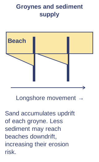
Groynes trap sediment moved by longshore drift, creating a wider beach that absorbs wave energy. They can reduce sediment reaching beaches farther along the coast, increasing erosion there.
Beach nourishment adds sediment, while reprofiling reshapes the beach to absorb wave energy. These preserve a more natural appearance but may require repeated work after storms.
Dune regeneration uses fencing, planting and controlled access to stabilise dunes. It can provide habitat and protection, but needs space and may limit recreation.
Managed realignment allows the shoreline to move inland in a planned area, sometimes by breaching old defences. New salt marsh can absorb energy, but landowners may lose land and need compensation.
Management decisions consider the value of assets, costs over time, habitats, sediment movement and climate change. Protecting one place can transfer problems elsewhere, so schemes need a wider coastal view.
UK coastline example: Dorset
Dorset's coast includes resistant headlands and less resistant bays. Around Swanage, resistant chalk at Ballard Point and limestone at Durlston Head contrast with less resistant rocks in the bay, helping explain its shape.
Old Harry Rocks near Handfast Point are chalk stacks and associated erosional features. Wave erosion along weaknesses separates parts of a headland, illustrating the cave–arch–stack sequence.
Swanage and Studland have depositional beaches. At Studland, wind-blown sand has formed dunes behind the beach, linking wave deposition, wind transport and vegetation growth.
The wider Dorset coast includes Chesil Beach, a long shingle barrier enclosing the Fleet lagoon along part of its length. Do not describe every Dorset beach as sand or every barrier as a simple spit.
UK management example: Walton-on-the-Naze, Essex
Walton-on-the-Naze is on the Essex coast facing the North Sea. Erosion and cliff slumping threaten land, access and heritage around the Naze, including the Naze Tower. The developed town frontage and the less developed Naze cliffs have different management needs.
Sea walls and groynes defend parts of the town frontage: walls resist wave attack and groynes trap sediment moving alongshore, maintaining a beach that absorbs wave energy. They require maintenance and can affect sediment supply farther along the coast.
Crag Walk opened in 2011 below the cliffs near the Naze Tower. Its rock revetment, a sloping layer of large rocks, absorbs and spreads out wave energy at the cliff foot, reducing undercutting locally, while the viewing platform provides access and interpretation. It protects a limited stretch rather than the entire Naze.
Residents, tourism businesses and visitors benefit from safer access and reduced risk to valued assets. Construction and repairs cost money; hard structures change the beach and natural erosion, and cannot guarantee permanent protection as sea level and storms change.
Much of the Naze remains exposed to natural erosion, which reveals internationally important geological layers and fossils. Decisions balance homes, heritage, access and habitats against cost and sediment effects. Contrast defended sections with retreat elsewhere rather than describing the whole coast as protected.
Test yourself
51 questions · Random sets of 10. These quick checks support revision; practise longer explanations and justified judgements too.
Mind map
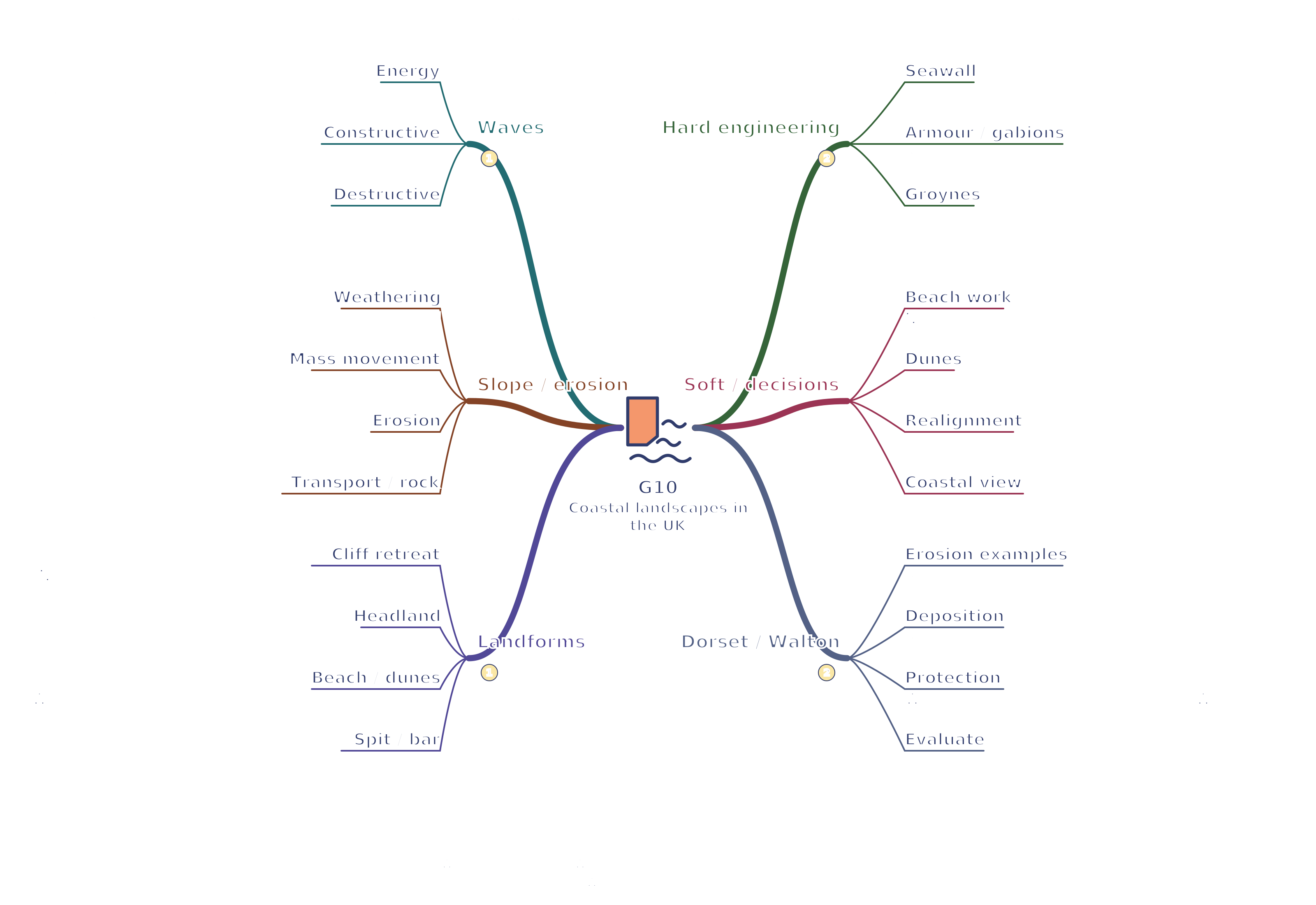
Use the branches to recall the ideas and explain their connections. Check the revision notes for the full detail.
View G10 mind mapOpen the full-size map to zoom. Use the printable view for A4 landscape or enlarge to A3.
 Mr Kidman's Classroom