Hazard and disaster — A natural hazard is a potentially damaging geophysical, atmospheric or hydrological process. A disaster occurs when an event seriously disrupts an exposed community beyond its capacity to cope using its own resources. A large event in an unoccupied area can have few human losses, while a smaller event can be disastrous where vulnerability is high.
Magnitude, intensity and frequency — Magnitude describes an event's overall size using the appropriate scale; intensity describes effects or strength at a particular location. Frequency is the number or rate of occurrences over a stated period. These measures are not interchangeable: one earthquake has a magnitude estimate but its shaking intensity varies spatially.
Exposure and vulnerability — Settlement location determines who or what lies in a hazard pathway, while building quality, poverty, health, governance and access to warning influence susceptibility and response. National income can affect capacity but conceals inequalities. Do not infer that everyone within a wealthy country is safe or that people in lower-income communities lack knowledge or agency.
Perception and decision-making — Experience, education, trust, religion, cultural attachment, livelihood needs and information shape how people interpret risk. A person remaining near a volcano may value farming or family networks, lack affordable alternatives, or judge the warning differently. Residence alone does not prove ignorance, fatalism or voluntary acceptance of every consequence.
Fatalism and prediction — Fatalism treats events or outcomes as largely unavoidable, potentially limiting action but not describing every cultural belief. Prediction seeks to identify the location, time and scale of a future event; probabilistic forecasting estimates likelihood under stated conditions. Neither a long-term forecast nor a retrospectively selected coincidence is a reliable exact prediction.
Adjustment and risk sharing — Adjustment includes changes to behaviour, design and land use that reduce harm, such as evacuation planning or retrofitting, which means strengthening an existing building or structure. Insurance and mutual support share financial burdens but do not prevent ground movement; premiums and eligibility can exclude vulnerable groups. Compare reduced exposure, reduced vulnerability and redistributed loss rather than calling every response prevention.
The Park model — The Park response model sketches disruption and changing quality of life through relief, rehabilitation and reconstruction. It can compare depth of impact and speed or completeness of recovery. Its smooth curve is a conceptual simplification: groups recover unevenly, repeated events can interrupt recovery and a pre-event baseline may already be unequal or unsustainable.
Hazard management cycle — Preparedness, response, recovery and mitigation describe linked activities rather than a strict one-way timetable. Rescue can overlap with temporary shelter and rebuilding; lessons can inform codes and training before another event. A cycle helps organise action but can conceal continuing vulnerability and political decisions about whose recovery is prioritised.
Earth structure, plate movement and landforms
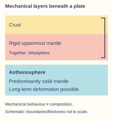
Mechanical and compositional layers — The lithosphere consists of crust and rigid uppermost mantle divided into moving plates. Beneath it, the asthenosphere can deform over geological time while remaining predominantly solid. Do not describe the mantle as a global liquid ocean carrying floating continents: mechanical behaviour and compositional layers are different classifications. This mechanical division cuts across compositional layers: the silicate crust and mantle surround an iron-rich core. The outer core is liquid; the inner core is solid under immense pressure. Oceanic crust is generally thinner and denser than continental crust, while both belong to the moving lithosphere.A mechanical classification does not make the asthenosphere a global liquid ocean. The simplified layers have no scale and do not show the whole Earth.
Internal energy — Residual heat from Earth's formation and heat from radioactive decay contribute to internal energy and mantle circulation. Heat loss, density differences and gravity connect deep processes to plate movement. The core is not a single open furnace directly pushing every plate in a simple circular conveyor at an identical speed.
Plate motion and evidence — Matching continental geology, ocean-floor ages, magnetic stripes, earthquake distributions and direct geodetic measurements support plate tectonics. Younger oceanic crust lies near spreading ridges and older crust farther away, subject to later subduction. One line of evidence is not the complete theory; converging independent observations strengthen explanation.
Ridge push and gravitational sliding — New lithosphere near a ridge is elevated and hot; as it cools and thickens away from the ridge, gravity contributes to motion down the broad slope. Ridge push is not magma acting as a rigid piston against an entire continent. Forces differ among plates and interact with mantle flow and boundary resistance.
Slab pull — Cold dense oceanic lithosphere sinking at a subduction zone can pull the attached plate. Density and thermal history matter; continental lithosphere is relatively buoyant and behaves differently in collision. Slab pull, gravitational sliding and mantle circulation form a connected system, not three mutually exclusive labels selected without context.
Constructive margins — Plates moving apart allow mantle material to rise and partially melt through reduced pressure, generating new oceanic crust at ridges. Shallow earthquakes and mainly basaltic volcanism accompany spreading. Continental extension can thin crust and produce rift valleys before an ocean basin develops; a rift is not a deep-sea trench.
Destructive margins and melting — At convergent margins, oceanic lithosphere can descend beneath another plate. Released fluids help lower the melting temperature of material above the slab, generating magma; the whole slab does not simply melt into a continuous liquid layer at the trench. Earthquakes extend down the descending slab while volcanoes commonly form farther inland.
Convergent landforms — Subduction can produce a deep-sea trench, an oceanic island arc or a continental volcanic margin. Collision of buoyant continental masses thickens and deforms crust into young fold mountains, with strong seismicity but not the same typical arc volcanism. Identify the plates and process rather than assigning every convergence an identical landform set.
Conservative margins — Plates slide laterally past one another along transform systems, with friction and locking allowing strain to accumulate before rupture. Crust is not systematically created or destroyed at the boundary. Earthquakes can be powerful and shallow; an absence of typical boundary volcanism does not mean low risk.
Hotspots and magma plumes — Some volcanism occurs away from present plate boundaries and is commonly explained using mantle upwelling or hotspots. Motion of a plate over a relatively persistent source can produce an age-progressive volcanic chain. Sources can also change or move, and not every island chain proves a perfectly stationary plume or a uniform plate speed.
Volcanic processes, impacts and management
Magma behaviour — Silica content, temperature, crystals, dissolved gas and ascent conditions influence magma viscosity, its resistance to flow, and eruption style. Gas can escape more readily from some low-viscosity magmas, while retained gas can drive explosive fragmentation. A volcano's behaviour can change; calling an entire volcano gentle or violent without conditions oversimplifies the hazard.
Lava flows — Lava is molten rock at the surface; flows can bury buildings, roads and farmland, redirect drainage and ignite material. Speed and reach depend on viscosity, discharge, slope and cooling. Many flows allow evacuation before arrival, but this does not make them harmless or mean that all flows move at the same rate.
Tephra and ash fallout — Tephra comprises fragmented material ejected by an eruption; ash is its fine fraction. Wind and eruption-column conditions distribute fallout beyond the vent. Ash can load roofs, affect breathing and visibility, contaminate water and disrupt aviation; it is fragmented rock/glass rather than soft combustion ash.
Pyroclastic density currents — Hot mixtures of particles and gas can move rapidly downslope following column or dome collapse or explosive activity; nuées ardentes are a traditional term associated with such hot glowing clouds. Dense and more dilute components can behave differently. Their temperature, speed and reach make exclusion and evacuation more realistic than trying to outrun an approaching flow.
Lahars — Water mixed with volcanic sediment can form a damaging flow along valleys, triggered by rainfall, melting snow/ice, crater-water release or other processes. Lahars can occur after an eruption and beyond the immediate vent area. A dry lava-flow map alone is insufficient to identify their pathways.
Gas and acid effects — Sulfur dioxide can affect air quality and contribute to acidic deposition; carbon dioxide can accumulate dangerously in low areas under suitable conditions. Gas hazards depend on emission, wind, chemistry and topography. A clear sky or an end to visible lava does not guarantee every area is safe to enter.
Volcanic distribution and magnitude — Volcanism concentrates at spreading and subduction settings but also occurs at intraplate hotspots. The Volcanic Explosivity Index combines indicators such as erupted volume and column height for explosive events; it does not directly measure every lava-flow or gas impact. Frequency and style at one volcano do not transfer automatically to another.
Monitoring and forecasting — Seismicity, deformation, gas, thermal observations and past deposits can indicate changing activity and inform probabilistic forecasts. Signals can have several causes and do not give an infallible time, size and pathway. Monitoring needs communication, trust, evacuation access and reviewable exclusion zones to become effective protection.
Volcanic impacts and recovery — Direct burial, burns and ash damage can cause cascading effects through transport, livelihoods, water, displacement and governance. Primary and secondary labels should explain the causal sequence, not replace it. Short-term evacuation and shelter can reduce casualties while long-term land loss and community recovery remain unresolved.
La Palma 2021 illustration — The 2021 eruption on La Palma in the Canary Islands began in September and continued into December; Spain's IGN records approximately 85 days and 8 hours of eruptive activity. Lava and ash affected an occupied island, illustrating that substantial property and livelihood damage can coexist with successful protective evacuation. This verified illustration is not an assertion of the school's selected volcanic event.
La Palma evidence and response — IGN monitoring and Copernicus mapping tracked deformation, lava extent and associated observations. Time-stamped maps supported emergency decisions, but an early map is not a final loss total and mapped exposure is not identical to confirmed destruction. Evaluate how monitoring, restricted access, communication and longer-term rebuilding address distinct needs; do not infer that the end of eruption removed residual gas or infrastructure risks.
Earthquakes, cascading hazards and comparison
Elastic strain and rupture — Relative movement can lock a fault, storing elastic strain in surrounding rock until rupture releases energy as seismic waves. The focus or hypocentre is where rupture starts; the epicentre is the surface point vertically above it. A rupture extends across an area and time, so the epicentre is not the only location experiencing strong shaking.
Seismic waves — P waves compress and expand material and can travel through solids and fluids; S waves shear material and cannot propagate through liquids in the same way. Surface waves and local wave interactions can produce damaging motion. Damage depends on shaking characteristics and structures, not simply which wave arrives first.
Moment magnitude and shaking intensity — Moment magnitude relates to rupture area, slip and rock rigidity and is logarithmic. About one magnitude unit corresponds to roughly 32 times the released seismic energy, not 32 times every local damage measure. Local intensity depends on distance, depth, path, geology, duration and construction as well as event size.
Site amplification and liquefaction — Soft sediments can amplify selected shaking frequencies. In suitable loose saturated sediments, cyclic shaking can raise pore pressure and reduce effective strength, causing settlement, spreading or foundation failure. Liquefaction does not mean all soil permanently becomes a liquid or that every wet site experiences the same response.
Landslides and tsunamis — Shaking can destabilise steep slopes. A tsunami can arise when rapid displacement of the seabed or another process displaces a substantial water volume; not every offshore earthquake generates one. Tsunami wavelength and repeated surges differ from ordinary surf, and local arrival may leave little time for warning.
Aftershocks and probability — Aftershocks follow a mainshock sequence and can damage already weakened structures; their rate commonly decreases over time while significant events remain possible. Long-term hazard maps and conditional aftershock forecasts express probability. An earthquake cannot currently be predicted reliably by specifying its exact time, location and magnitude in advance.
Risk reduction and early warning — Codes, retrofitting, safe siting, lifeline redundancy (backup routes or supplies for essential services), drills and trained response can reduce losses. Earthquake early warning detects rupture already underway and may give seconds before stronger shaking reaches a location; it is not prediction before the earthquake begins. A tsunami warning also requires understood instructions and feasible evacuation routes.
Türkiye–Syria 2023 illustration — On 6 February 2023, a major earthquake sequence affected southern Türkiye and northern Syria; USGS reports magnitude 7.8 and 7.5 events. Shallow strike-slip rupture, widespread exposure, vulnerable buildings and winter conditions contributed to severe disruption. Cross-border political and humanitarian conditions affected response, so a magnitude-only account is inadequate. The event is a verified illustration rather than a confirmed staff case-study choice.
Dated damage evidence — The World Bank's 27 February 2023 rapid assessment estimated US$34.2 billion in direct physical damage in Türkiye, about 4% of its 2021 GDP. This is a dated estimate for a specified country and measure, not a final combined loss total for Türkiye and Syria or a sum including every indirect livelihood cost. Reconstruction requirements can differ from the value of direct damage.
Evaluating earthquake recovery — Search and rescue, medical care, shelter and restoring services overlap with longer-term inspections, demolition, reconstruction and livelihood support. Aftershocks complicate access, while enforcement, tenure and affordability affect safer rebuilding. Compare actual indicators and groups rather than treating a new building count as proof that all households recovered equally.
Tōhoku 2011 comparison — The 11 March 2011 offshore Tōhoku event was a subduction earthquake, listed by USGS at magnitude 9.1; some Japanese records use 9.0. The tsunami caused destructive inundation and a cascading nuclear emergency at Fukushima. This older comparison demonstrates the limits of assuming high national income or substantial engineering removes extreme-event and cascading risks; it is not substituted for the more recent seismic illustration.
Multi-hazard connections — One process can trigger another, such as earthquake damage to transport and power affecting evacuation or water supply. Several independent hazards can also affect the same place over time. Distinguish a cascade from simple co-location, and assess compounding exposure, recovery interruptions and the capacity of shared infrastructure.
Living with tectonic hazards — Fertile soils, geothermal resources, tourism, jobs, transport links and attachment can sustain occupation despite hazard. Benefits and constraints differ among households and may change after an event. Evaluate resilience, adaptation, mitigation and risk sharing together rather than assuming residence is irrational or every resident has an unconstrained choice to leave.
Worked probability and comparison — In fictional data, 12 damaging events over 60 comparable observation years give a mean rate of 0.2 per year, not a schedule promising an event every fifth year. A notional one-in-100 annual exceedance probability is 1% in a year, not a guarantee of a 100-year safe interval. Record the assumed stability, event definition and incomplete-history limits.
Judging tectonic risk — A defensible comparison connects source process, magnitude, local intensity, population, vulnerability, cascading impacts and governance. Use dated compatible measures and explain missing data. Evaluate preparedness and recovery against explicit criteria, separating probability forecasts, exact predictions, observed outcomes and plausible mechanisms.
Test yourself
50 questions · Random sets of 10. These quick checks support revision; practise longer explanations and justified judgements too.
 Mr Kidman's Classroom