Population distribution and environmental relationships
Distribution and density — Population distribution describes where people live; arithmetic density divides population by land area. The same density can result from a compact city or scattered settlements, and a national average conceals local contrasts. Specify the boundary, date and area definition before using density to explain environmental pressure.
Numbers and change — Population size is a stock at a stated time; births, deaths and migration are flows changing it. A large population can have a low growth rate, while a small population can grow rapidly in percentage terms. Compare absolute change and rate rather than treating them as interchangeable measures of pressure.
Climate and settlement — Temperature, precipitation, seasonality and extremes influence water, health, agriculture and building needs. Technology, trade, institutions and livelihoods mediate those relationships, so a harsh climate does not mechanically determine low settlement or poverty. Explain the enabling resources and costs as well as the physical constraint.
Soils, water and resources — Soil depth, drainage, nutrients and water availability affect productive opportunities, while energy/mineral resources and connectivity can support concentrated settlement elsewhere. Resource distribution is not identical to access: infrastructure, rights, affordability and governance affect who can use an available resource.
Development and environmental change — Transport, irrigation, health services, urbanisation and trade can change the relationship between population and local resources. They can reduce some constraints while creating pollution, import dependence or unequal access. Treat development as a process with uneven effects rather than a single national label that explains every outcome.
Reciprocal relationships — People alter environments through land clearance, abstraction, emissions and management, while environmental change affects livelihoods, health and movement. Impacts depend on consumption, technology and institutions as well as population size. A correlation between high density and damage does not establish population numbers as the only cause.
Agricultural systems, climate and zonal soils
Agricultural systems — Farming systems combine inputs such as land, labour, water, capital and knowledge with processes and outputs. Subsistence production mainly meets the producer’s own needs; commercial production mainly supplies a market. Extensive farming uses relatively few inputs per unit area; intensive farming uses more. Arable farming grows crops, while pastoral farming raises livestock. These labels describe different dimensions. A farm can sell surplus and feed its household; these labels need not form mutually exclusive boxes.
Productivity and yield — Crop yield is output per unit of cropped area, while labour productivity is output per worker and total output is the quantity produced. A small intensive farm can have high yield but low output per worker. State the denominator before comparing systems or claiming greater efficiency.
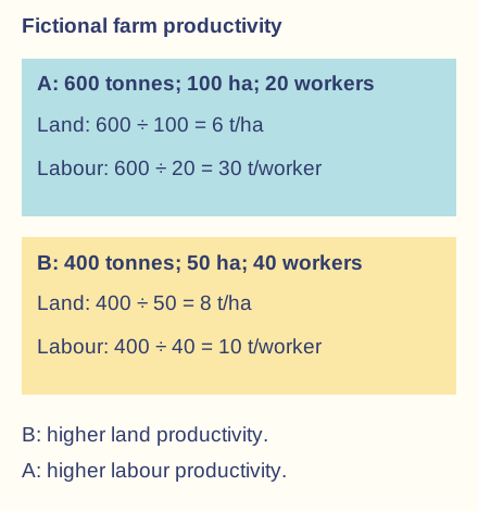
Worked agricultural comparison — In fictional data, Farm A harvests 600 tonnes from 100 hectares with 20 workers: 6 t/ha and 30 t per worker. Farm B harvests 400 tonnes from 50 hectares with 40 workers: 8 t/ha and 10 t per worker. B has higher land yield; A has higher labour productivity and total output. The comparison omits costs, nutritional value and environmental effects.Fictional comparable-period totals show why higher yield per hectare does not imply higher output per worker. These indicators alone establish neither profit nor food access.
Physical controls on production — Growing-season temperature, water supply, sunlight and extreme events interact with rooting depth, soil structure and nutrients. Irrigation or protected cultivation can modify conditions but requires resources and management. Neither fertile soil without water nor warm weather beyond a crop's tolerance guarantees high yields.
Climate types as comparative models — Two contrasting climatic illustrations help test agriculture–environment relationships: tropical wet-and-dry climates and temperate maritime climates. Each covers varied places and changes with altitude, coast and circulation. They are explanatory examples, not an assertion that staff selected these exact climatic study types; apply the mechanisms to the setting specified in a question.
Tropical wet-and-dry pattern — In tropical wet-and-dry settings, high temperatures combine with marked rainfall seasonality associated with shifting circulation. Seasonal moisture can support crop growth but restrict planting and grazing during dry periods; unreliable onset and intense rain create additional risks. Storage, crop choice and livelihood timing mediate the effect on people and food.
Temperate maritime pattern — Temperate maritime climates, such as the UK's broad setting, have relatively moderated temperatures and precipitation through much of the year, modified by relief and exposure. These conditions can support mixed farming, pasture and temperate crops. Wet harvesting periods, waterlogged soils, drought episodes and short cool seasons remain possible; maritime does not mean uniformly favourable weather.
Interpreting climate graphs — Compare monthly temperature and precipitation, annual range, seasonality and likely growing-season water stress. Monthly means conceal storm intensity, frost dates and year-to-year variability. A suitable graph supports a conditional crop explanation, not proof that every farm in the region uses the same system.
Zonal soil concept — Zonal soils reflect broad climate and vegetation influences over time, but parent material, relief, drainage, organisms and human use create local variation. A soil profile has horizons with different organic matter, minerals and structure. Ferralsols and Chernozems provide contrasting verified illustrations rather than assumed school-selected soil case studies.
Ferralsol characteristics — Ferralsols occur mainly on old, strongly weathered tropical surfaces, with intense alteration and iron/aluminium-rich material. Leaching is the downward removal of dissolved substances by water moving through soil. Prolonged leaching and low nutrient retention can constrain agriculture even under dense natural vegetation. The depth, stable microstructure and permeability of many Ferralsols mean they should not all be described as shallow impermeable soil.
Ferralsol nutrient cycling — Rapid biological cycling can hold much available nutrient in living biomass and litter rather than a large readily available mineral store. Clearing vegetation and exporting crops disrupt this cycling. Fertiliser, organic inputs, suitable crop systems and careful management can sustain production under some conditions; natural limitations do not mean successful farming is universally impossible.
Chernozem characteristics — Chernozems develop in many temperate grassland settings, with a dark organic-rich surface horizon and generally favourable structure and nutrient conditions. Roots and decomposition contribute organic matter; climatic water balance helps limit extreme leaching. Their broad association with productive farmland does not remove local drought, erosion or management constraints.
Comparing soil and use — Ferralsols and Chernozems contrast in weathering history, organic matter distribution, nutrient retention and water conditions. Connect those properties to crop and management requirements, not just colour. A zonal map cannot substitute for the actual soil profile, drainage, slope and land-use evidence of one field.
Soil degradation, climate change and management
Water erosion — Rain impact and runoff can detach and move soil, especially where cover is removed and flow concentrates. Loss of nutrient-rich topsoil can reduce productivity and add sediment downstream. Explain intensity, slope, structure and management together; annual rainfall total alone cannot determine the rate.
Wind erosion — Dry, loose, exposed soil can be entrained by wind, particularly where protective cover is sparse. Loss of fine material and organic matter can reduce fertility, while dust affects neighbouring places. Soil moisture, aggregate stability, wind exposure and land management determine susceptibility rather than low rainfall alone.
Erosion management — Ground cover, contour cultivation, terraces where suitable, reduced disturbance and windbreaks can slow detachment or transport. Design must fit slope, rainfall, soils, labour and land rights; badly maintained terraces can fail or concentrate flow. Evaluate effectiveness and feasibility rather than treating one technique as universally available.
Waterlogging — Persistent saturation reduces air-filled pores and can deprive roots of oxygen, impairing growth and machinery access. Heavy soil, compaction, low relief or excessive irrigation can contribute. Drainage may improve conditions but can export pollutants, affect wetlands and require maintenance; removing water is not costless in every setting.
Salinisation — Salts can accumulate where water containing dissolved salts enters a soil and evapotranspiration removes water faster than salts are flushed away. Irrigation without adequate drainage can raise a saline water table and concentrate salts near roots. Distinguish salinity (high soluble-salt content), waterlogging (persistent saturation) and sodicity (a high proportion of sodium on soil exchange sites, which can damage soil structure), even where they occur together.
Managing salts and drainage — Appropriate irrigation scheduling, drainage, suitable water quality and salt-tolerant crops can reduce impacts under some conditions. Leaching salts requires sufficient suitable water and a safe drainage destination; it does not destroy the salts. Consider downstream water quality, costs and access rather than recommending unlimited irrigation.
Structural deterioration — Compaction reduces pore space and can restrict infiltration, aeration and root growth; excessive traffic on wet ground can contribute. Organic-matter loss and aggregate breakdown can increase crusting and runoff. Reduced traffic, appropriate timing, cover and organic inputs address mechanisms but their feasibility depends on local farm conditions.
Climate change and crop response — Changing temperature, rainfall, drought, flood and pest conditions alter growing opportunities and risks. Some cooler settings may gain longer seasons while heat and water stress reduce suitability elsewhere. Elevated carbon dioxide is not a guarantee of higher nutritious output because water, nutrients, extremes and crop responses constrain benefits.
Adaptation and trade-offs — Changed varieties, planting dates, diversification, water management and better forecasts can reduce selected risks. Costs, knowledge, tenure and access make adoption unequal; an effective adaptation at one farm can increase regional water pressure. Evaluate limits and possible maladaptation, where a response increases vulnerability or creates new harm rather than equating more technology with universal resilience.
Food-system emissions and feedback — Agriculture and food systems affect climate through land-use change, energy, methane, fertiliser-related emissions and supply chains. Environmental change then affects production and access. Compare demand, waste, management and livelihoods rather than assigning responsibility solely through the number of consumers or only through production at the farm gate.
Food patterns, access and security strategies
Production and consumption patterns — Food production reflects physical suitability, technology, labour, markets and policy, while consumption reflects income, culture, prices, health and availability. Trade links different regions' needs and supply, with feed, processing and waste affecting how much reaches people. High national output does not automatically mean an adequate diet for every household.
Availability and access — Availability concerns food physically supplied through production, stocks, trade or aid; access concerns whether people can obtain it through income, entitlements and practical routes. A market can contain food that a poor household cannot afford. An import bill or a grain tonnage alone therefore does not establish food security.
Utilisation and stability — Utilisation includes dietary quality, preparation, safe water, health and the body's ability to use food. Stability concerns continuity of availability, access and utilisation through seasons and shocks. A short adequate supply can coexist with an annual hunger season or unreliable income.
Undernutrition and changing diets — Insufficient energy, micronutrient deficiencies and unbalanced diets have different causes and effects; overconsumption and diet-related illness can coexist with hunger within one country. Compare household and individual differences by age, income, health and gender. Average national calories conceal diet quality and distribution.
Raising production — Improved seed, soil management, irrigation, infrastructure and knowledge can increase supply where the limiting conditions are addressed. Inputs require affordability, suitability and environmental appraisal. Increased output may fail to reach food-insecure people if price, conflict, rights or distribution remain barriers.
Trade, stocks and market resilience — Trade can compensate for local shortfalls and diversify supply, while storage can bridge seasons. Dependence on a few suppliers, foreign exchange, transport or export-policy changes can create vulnerability. Evaluate diversification, reserves and access rather than assuming complete self-sufficiency or unlimited imports is always best.
Social protection and distribution — Cash, food transfers, school meals and livelihood support can improve access for vulnerable groups when designed for local markets and needs. Delivery, targeting, corruption, conflict and price effects require evaluation. A published entitlement is not proof that every eligible person receives adequate support on time.
Reducing losses and waste — Storage, cooling, transport and processing can reduce losses before retail, while purchasing and consumption practices influence later waste. Measures can improve effective supply without identical increases in cropped area. Costs, energy, food safety and who benefits must be assessed, and avoided waste does not automatically transfer food to every hungry person.
Diet diversification and sustainable systems — Diverse crops, rotations and appropriate mixed systems can spread risk, support nutrition and maintain some ecological functions. Trade-offs include labour, market demand and income during transition. A resilient strategy combines suitable production, environmental management and fair access rather than relying on one yield or one label.
Worked supply and access example — In fictional data, 1,000 tonnes of grain are harvested and 150 tonnes lost before sale, leaving 850 tonnes. Reducing loss to 100 tonnes adds 50 usable tonnes without additional harvest. Whether food security improves depends on prices, distribution, nutritional needs and stable access; tonnage alone does not determine the welfare outcome.
Evaluating geographical claims — Specify the scale, date, denominator and evidence for production, consumption, density or hunger. Compare climate/soil mechanisms with institutions, technology, trade and unequal access. A defensible judgement identifies both environmental constraints and human capacity, with assumptions and limits rather than environmental determinism.
Test yourself
50 questions · Random sets of 10. These quick checks support revision; practise longer explanations and justified judgements too.
 Mr Kidman's Classroom